When locating a new well, finding the water is only part of the challenge. Making sure that water that the well produces is clean – and is likely to stay clean – is the other vital component of a successful well installation.
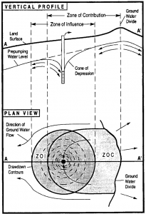
The capture zone of wells and the potential to draw in contaminants is dependent on topography, geology, pumping rates and other vulnerability factors. There are two concepts that must be understood to determine the potential for contaminants to impact a well:
 Zone of Contribution (ZOC) – The area surrounding a pumping well that encompasses all areas or features that supply ground-water recharge to the well.
Zone of Influence (ZOI) – The area surrounding a pumping well within which the water table or Potentiometric Surfaces has been changed due to ground-water withdrawal.
Once the ZOC and ZOI are defined based on the well characteristics, the next steps are to determine wellhead protection areas and an overall Source Water Assessment Plan (SWAP).
Wellhead protection areas protect public water systems using ground water from contamination from sources such as industrial spills, shallow underground injection discharges {referred to by EPA as class V (5) wells} through wells, floor drains and septic tanks, leaks from underground storage tanks, etc. Wellhead protection zones are designed based on the underlying geology, well design and the zone of contribution and zone of influence which determine the potential for activities in the wellhead protection area to impact the well.
Source water assessments are usually made prior to construction of a public water system well and periodically during the lifespan of well operation. Source assessments
- Delineate source water and wellhead protection area;
- Develop a baseline of water quality and quantity information;
- Catalog an inventory of activities and potentially contaminating activities (PCAs) in the source water protection area; and,
- A risk assessment to determine the potential vulnerability to contamination from the identified potential sources.
BesidesPCAs, well construction can also determine the vulnerability of the well, with older wells, shallower wells, wells located in areas of high groundwater velocity and wells located in areas of rapid recharge considered to be the most vulnerable.
The 1996 Safe Drinking Water Act mandated Source Water Assessment Programs by each state, but most of these were completed in the early 2000s and changes to land uses and new PCAs have rendered many of these SWAPs out of date, potentially endangering water quality in those areas. Needless to say, new public water supply wells require a source water assessment, but existing wells generally are due to have their source water assessments updated, as well. Some regulatory jurisdictions mandate SWAP forms and the associated specific information must be completed for new wells.
Residential wells, due to their smaller production capacity, have smaller zones of contribution and zones of influence, but can still be impacted relative to their location with respect to things like septic systems, animal enclosures and other potential sources of contamination. It is important to identify and locate these potential contamination sources prior to siting a residential well.
Karst and areas with high rates of surface water infiltration are especially susceptible to surface contaminants. Groundwater movement in karst environments can be measured in miles per day in some circumstances, so it is important to understand flow paths relative to potential sources of contamination in karst conditions.
Proper establishment of wellhead protection areas and source water assessments can go a long way to assure that the groundwater produced from a water supply well is, and remains, clean over the life of the well.
