They say that the only thing certain about karst is its uncertainty, and that definitely holds true in Middle and East Tennessee. Even though karst geology does present some challenges in developing good producing wells, we can narrow the odds a bit by applying some basic hydrogeological techniques when trying to site a productive well.
Karst forms in relatively pure limestones or dolomites when rainwater combines with carbon dioxide in the atmosphere to form a weak acid called carbonic acid. This weak acid, over time, dissolves limestone and dolomite along zones of weakness such as bedding planes or fracture zones, creating conduits, caves and enlarged fracture zones. These conduits provide the secondary porosity that represents the main pathways for groundwater movement in karstic limestones.
Karst can be highly variable in its ability to transport water. If you drill into a well-developed karst conduit system, you can get plenty of water; but if you drill where there are no solution openings or interconnected cavities, you may get very little water. The tricky part is that these conditions can literally occur within tens of feet of each other.
Geology is important– Some limestone formation tend to develop more extensive karst features than others. Knowing the different geologic units and their tendencies for strong karst development can improve the odds for siting a good well. For instance, the St. Louis Limestone on the Eastern Highland Rim tends to development significate karst features that can carry large volumes of water in many places.
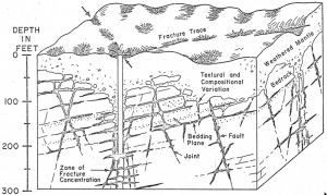 Fracture trace and lineament analysis– This is a multistep process using topographic maps and aerial photography followed by “ground truthing” to determine whether the identified linear features are indeed faults or fracture traces. Alignment of linear features may be evidenced by differences in vegetation, streams flowing along a straight path and then making a sudden right angle turn, valley alignments and offsets. A related phenomenon, stress relief fracturing, is caused by unloading the pressures of overlying rocks by erosion. The pressure release from the removal of the overlying rock causes the bedrock to bow up and create fracture zones. Stress relief fractures tend to be best developed in valleys and are much less extensive on the tops of hills. Faults tend to offset the bedrock and can cause breakage over a fairly significant width and can occur at greater depths than stress relief fractures, allowing increased porosity for water to flow along the fault zone and dissolve the limestone to create karst conducts. Faults are rarely vertical, so it is important to understand which way they dip in order to intercept them at depth.
Dye tracer tests are good for determining the rate and direction of groundwater movement in an area, but are seldom useful for locating individual wells.
Generally, a combination of a well-applied fracture trace and lineament analysis along with understanding the characteristics of karst development in different geologic formations will allow for the best chance of developing a good producing well in Middle and East Tennessee.